Blog
Lake Effect Snow Warning: What It Means, Why It Happens, and How to Stay Safe

Introduction
A Lake Effect Snow Warning is one of the most impactful winter weather alerts issued by meteorological agencies. These warnings signal the potential for heavy, fast-accumulating snowfall, dangerous travel conditions, and rapidly changing weather—often within a very short distance.
Communities near large bodies of water frequently experience some of the most intense winter snowstorms due to this phenomenon. Understanding what a lake effect snow warning means, how it develops, and how to prepare can make a significant difference in safety and readiness.
What Is a Lake Effect Snow Warning?
A Lake Effect Snow Warning is issued when meteorologists expect significant snowfall caused specifically by lake effect processes. This type of snow is not associated with traditional winter storms but instead forms when cold air passes over warmer lake waters.
Key Characteristics of Lake Effect Snow
- Extremely heavy snowfall in narrow bands
- Rapid accumulation (several inches per hour possible)
- Sharp differences in snowfall totals over short distances
- Reduced visibility and whiteout conditions
A warning indicates that dangerous conditions are imminent or already occurring.

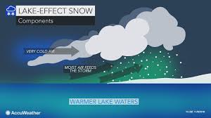
What Is Lake Effect Snow? Simple Explanation
Lake effect snow occurs when cold, dry air moves across warmer lake water. The temperature difference causes the air to pick up moisture and heat from the lake. As the air travels inland, it cools, moisture condenses, and intense snow bands form.
Why It Is So Powerful
- Warm lake water fuels snow clouds
- Cold air enhances instability
- Wind direction controls where snow bands hit
This process can continue for hours or even days, dumping massive amounts of snow on localized areas.
Where Do Lake Effect Snow Warnings Commonly Occur?
Lake effect snow warnings are most common near large lakes, particularly:
Great Lakes Region
- New York (Buffalo, Syracuse areas)
- Michigan
- Ohio
- Pennsylvania
- Indiana
- Wisconsin
Other Global Locations
- Areas near large inland seas or cold-water lakes
- Coastal regions with similar temperature contrasts
Communities downwind of lakes are especially vulnerable.
Lake Effect Snow Warning vs Advisory vs Watch
Understanding the difference between alerts helps assess urgency:
⚠️ Lake Effect Snow Watch
- Conditions are favorable
- Potential for heavy snow in the future
🟨 Lake Effect Snow Advisory
- Moderate snowfall expected
- Travel may become difficult
🚨 Lake Effect Snow Warning
- Heavy snowfall imminent or ongoing
- Dangerous or life-threatening conditions possible
A warning requires immediate attention and preparation.

How Much Snow Can Fall During a Lake Effect Snow Event?
Lake effect snow is notorious for extreme totals:
- 6 to 12 inches in a few hours
- 2 to 4 feet during prolonged events
- Snowfall rates exceeding 2–4 inches per hour
Meanwhile, areas just a few miles away may receive little or no snow at all.
Why Lake Effect Snow Is So Dangerous
Lake effect snow events are hazardous because of their intensity and unpredictability.
Major Risks Include
- Sudden whiteout conditions
- Icy and snow-covered roads
- Vehicle pileups
- Power outages due to heavy snow load
- Stranded motorists
Travel can become dangerous within minutes, even on familiar routes.
How Long Does a Lake Effect Snow Warning Last?
A lake effect snow warning can last:
- Several hours
- Overnight
- Multiple days in persistent wind patterns
The duration depends on:
- Wind direction consistency
- Lake water temperature
- Strength of cold air mass
What To Do During a Lake Effect Snow Warning
🏠 At Home
- Stay indoors if possible
- Ensure heating systems are working
- Keep emergency supplies ready
- Clear vents and exhaust pipes
🚗 Travel Safety
- Avoid unnecessary travel
- Carry winter emergency kits
- Keep fuel tanks full
- Follow local road closures
❄️ If You’re Caught Outside
- Reduce speed immediately
- Use headlights and hazard lights
- Pull over safely if visibility drops
Why Lake Effect Snow Is Increasing in Intensity
Scientists suggest that climate variability may influence lake effect snow:
- Warmer lake temperatures increase moisture
- Delayed lake freezing extends snow season
- More intense short-duration snowfalls
This makes understanding warnings even more important for long-term preparedness.
Frequently Asked Questions (FAQ)
❓ Is lake effect snow worse than a blizzard?
It can be. While blizzards affect wide areas, lake effect snow can create extreme conditions in localized zones.
❓ Can lake effect snow happen without a storm system?
Yes. It often occurs under clear skies elsewhere, making it more dangerous due to lack of expectation.
❓ How accurate are lake effect snow forecasts?
Forecasting has improved, but small wind shifts can dramatically change snowfall location.
❓ Does lake effect snow only happen in the U.S.?
No. Similar effects occur worldwide near large lakes and cold-water bodies.

How to Stay Updated During a Lake Effect Snow Warning
- Follow official weather alerts
- Monitor local news and emergency services
- Enable weather notifications on mobile devices
- Listen to community advisories
Real-time updates are critical due to the rapidly evolving nature of these events.
Conclusion
A Lake Effect Snow Warning is not just another winter alert—it is a serious signal of potentially dangerous weather conditions. With snowfall capable of reaching extreme levels in a short time, preparation, awareness, and caution are essential.
Understanding how lake effect snow forms and how it impacts travel and daily life empowers communities to respond effectively. When warnings are issued, proactive decisions can protect lives, property, and infrastructure.
Staying informed today ensures safer winters tomorrow.
Discover more from Mithu Tech Group
Subscribe to get the latest posts sent to your email.
